
Quick answer: A drone survey in India costs ₹100–500 per acre with a camera (photogrammetry) and ₹160–1,000 per acre with LiDAR, for sites of 200 acres or more. A LiDAR survey of a road, canal or pipeline corridor costs ₹5,000–10,000 per km for a 150 m wide strip. GST at 18% and travel are extra.
These are the rates TerraX charges on projects across India in 2026. Many cost guides online quote two to ten times more, and some give different figures in the same article. This guide gives one set of rates and explains what changes them.
How much does a drone survey cost in India?
| Survey type | Rate (before GST) | Best for |
|---|---|---|
| Camera survey (photogrammetry) | ₹100–500 per acre | Orthophotos, site plans, visual inspection |
| LiDAR survey | ₹160–1,000 per acre | Accurate ground levels, sites with trees or crops, drainage and flood studies |
| LiDAR corridor survey | ₹5,000–10,000 per km (150 m wide) | Roads, canals, pipelines, power lines |
| Minimum order | 200 acres | Smaller sites are billed as 200 acres |
Larger sites cost less per acre because the crew, travel and setup costs are shared over more area.
How much does a LiDAR drone survey cost by project size?
| Site area | Total cost (before GST) | Per acre | Per hectare |
|---|---|---|---|
| 200 acres | ₹60,000–2,00,000 | ₹300–1,000 | ₹741–2,471 |
| 500 acres | ₹80,000–3,50,000 | ₹160–700 | ₹395–1,730 |
| 1,000 acres | ₹2,00,000–5,00,000 | ₹200–500 | ₹494–1,236 |
| 5,000 acres | ₹8,00,000–15,00,000 | ₹160–300 | ₹395–741 |
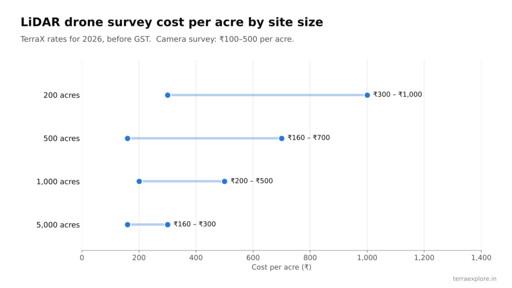
LiDAR survey cost per acre by site size (TerraX 2026 rates, before GST).
Per square km, a LiDAR survey of a large site works out to about ₹40,000–1,24,000. A camera survey works out to about ₹25,000–1,24,000 per square km. For a detailed LiDAR guide, see LiDAR Survey Cost in India.
What is included in the price?
Included:
- Checking the airspace zone before the quote, and flight permission in green and yellow zones
- Ground control points measured with DGPS (5–6 per square km) [to confirm: included in price?]
- Data capture, processing and quality checks
- Orthophoto, DTM, DSM, contours, 3D model and CAD drawing, at no extra charge
- Classified point cloud (LAS) for LiDAR surveys
- Free corrections for any error on our side, and data kept for 2 months
Charged extra:
- GST at 18%
- Travel at ₹20 per km outside Ahmedabad, plus boarding and lodging for the crew
- Feature mapping (buildings, trees, poles, roads, drains)
Delivery takes 5 days for sites under 100 acres and 8 days for sites up to 5,000 acres.
What affects drone survey cost?
- Area. The minimum order is 200 acres. Above that, the rate per acre falls as the area grows.
- Survey type. LiDAR costs about 1.5–2 times a camera survey. The gap used to be wider; newer LiDAR sensors have brought it down.
- Accuracy needed. Tighter accuracy needs more ground control points and more checks.
- Site access and weather. Rivers, mines, saline land and harsh climate cut the area the crew can cover in a day. More days on site means higher boarding and lodging costs.
- Location. The per-acre rate is the same across India. Only travel (₹20 per km outside Ahmedabad) and stay change.
- Airspace zone. Green and yellow zones are handled by the survey team. Red zones need the client’s help to get permission from the Central Government, which adds time.
- Extra deliverables. Feature mapping of buildings, trees, poles and drains is charged separately.
- Repeat surveys. Repeat surveys of the same site get a 10–20% discount.
Drone survey cost by use case
| Use case | Usual method | What decides the cost |
|---|---|---|
| Construction site, township, TP scheme | LiDAR or camera | Area, feature mapping, contour interval |
| Solar plant | LiDAR, priced per acre | Area; ground levels for grading and drainage |
| Mine, quarry, stockpile | Camera or LiDAR | How often you survey. A web-based volume app is free for one month with the survey |
| Road, canal, pipeline, power line | LiDAR corridor | Length and width: ₹5,000–10,000 per km for 150 m wide |
| Flood and drainage study | LiDAR | Ground levels under trees, crops and other cover |
Every project is priced on its area, complexity and purpose. Send a KML file for an exact quote.
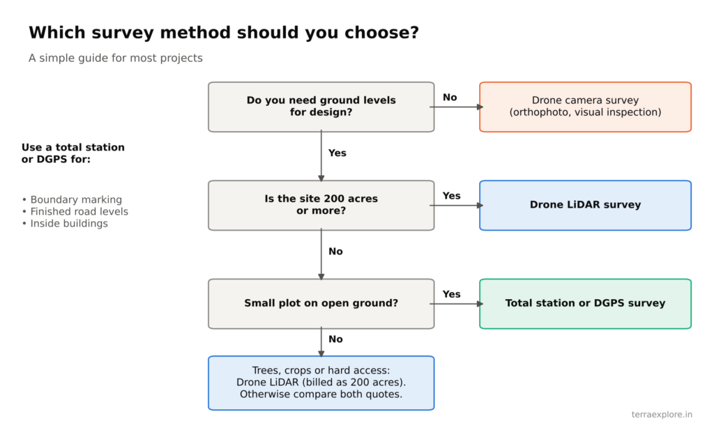
A simple guide to choosing a survey method.
Is a drone survey cheaper than a traditional survey?
Yes, for sites above 200 acres. A ground crew with a total station or DGPS covers about 12–25 acres a day on flat, open land. A drone covers up to 1,000 acres a day.
| 500-acre site | Total station or DGPS | LiDAR drone survey |
|---|---|---|
| Cost (before GST) | ₹12.5–50 lakh | ₹0.8–3.5 lakh |
| Field time | 20–40 crew-days | 1 day |
| Ground points measured | About 20,000 (one every 10 m) | 400–800 million (200–400 per sq m) |
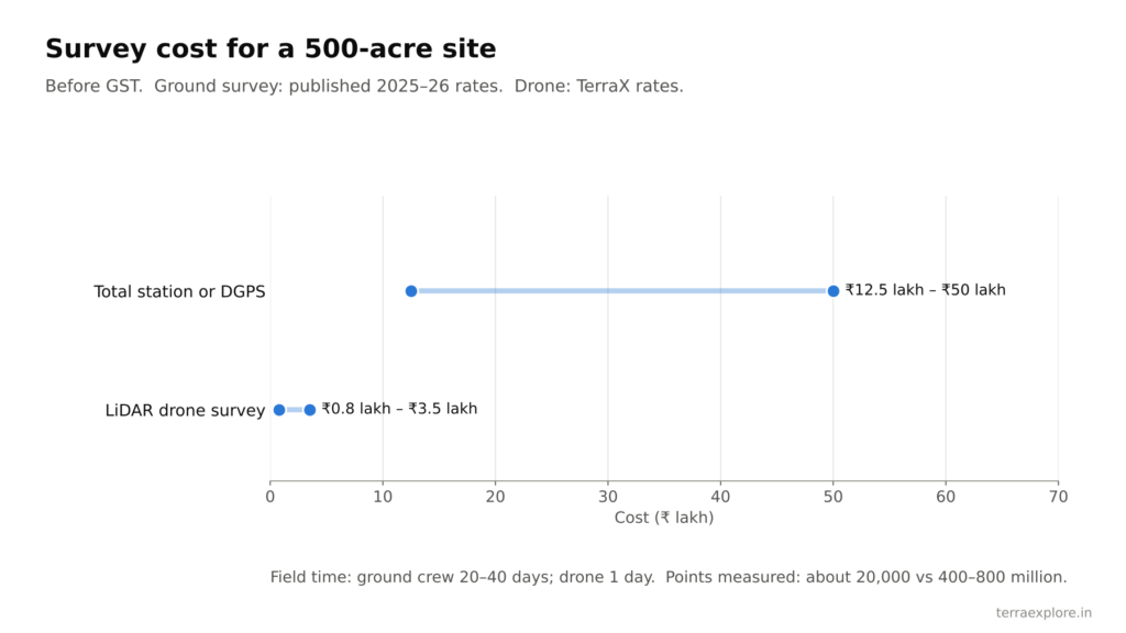
Survey cost for a 500-acre site, before GST.
Traditional rates are from published 2025–26 survey cost guides (₹2,500–10,000 per acre). Ground survey is still the better choice for small plots, boundary marking and work inside buildings. See Drone Survey vs Traditional Survey for the full comparison.
How to lower your drone survey cost
- Be clear about the purpose. The purpose decides the method and the deliverables. You avoid paying for outputs you will not use.
- State the accuracy you need. Ask for it in writing, along with the number of ground control points and an independent check report.
- Send complete details. A KML file, the area, the purpose and the list of deliverables get you an accurate quote quickly.
- Plan repeat surveys together. Booking repeat visits to the same site brings the cost down by 10–20%.
- Choose a team that gets it right the first time. An error found later in the project costs far more than the survey itself. Ask whether the company flies and processes the data with its own team, or sends the data to a third party.